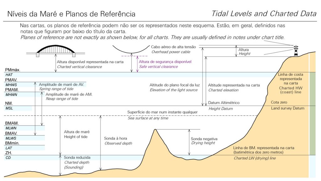
Hydrographic Zero
Hydrographic Zero
The Hydrographic Zero (ZH.) Is a conventional reference plane, located below the Lower Astronomical Tide (BMmin) level, to which the probes and the isobathymmetric lines represented in the nautical chart are referred, as well as the tide height forecasts published in the Tide Tables of the Hydrographic Institute.
The main objective of its implementation is the practice of maritime navigation with a view to its safety.
In continental Portugal the ZH. is established 2.00 m below the average adopted sea level (NMA) - Cascais 1938, being an exception case the port of Lisbon where the value of 2.08 m is considered.
In the Madeira Archipelago the ZH. is located 1,40 m below the NMA for the maregráfica station of the port of Funchal (Funchal, 1913).
In the Archipelago of the Azores, the ZH. were established 1.00 m below the NMA for the following tide stations:
- Santa Maria island - Vila do Porto, 1965;
- S. Miguel island - Ponta Delgada , 1991;
- Terceira e Graciosa islands - Angra do Heroísmo, 1951;
- S. Jorge, Pico e Faial islands - Horta, 1935;
- Corvo e Sta. Cruz das Flores islands - Sta. Cruz das Flores, 1965.
Similarly, for Lusophone African countries, there are several ZH's. established in relation to the tide stations implemented.
The values used in mainland Portugal and in the archipelagos of Madeira and the Azores, as well as in the Portuguese-speaking African countries, are included in the "Tide Table" published annually by the Hydrographic Institute and available for download at http://www.hidrografico.pt/tabelamares or for sale at Loja do Navegante (http://loja.hidrografico.pt/).


