Multibeam sounder
Multibeam sounder
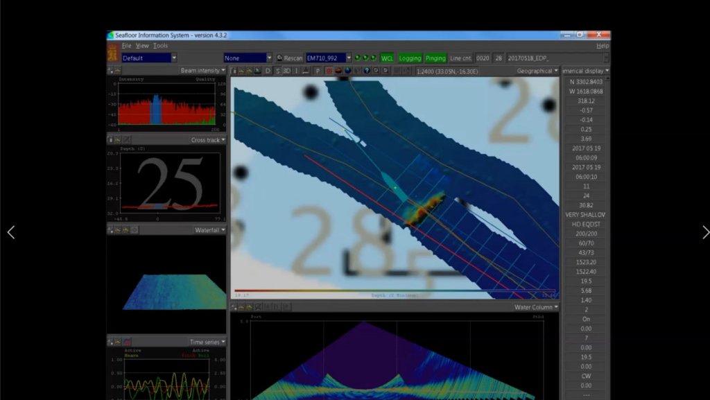
The film here presented corresponds to the screenshot of the software that allows the visualization of data obtained directly from the multibeam echosounder used during the Hydrographic Institute SEDMAR mission, which took place in May 2017, on board the NRP "Almirante Gago Coutinho" hydrographic vessel in the Madeira Sea.
On the screen, it is possible to observe, from the data obtained from the multibeam, the NRP "General Pereira d'Eça" location sunk in 2016, just outside Porto Santo, in order to create an artificial reef.
There is a great diversity of equipment for the seabed study. However, it is the acoustic sounders that, qualitatively, allow the measurement of depths with high accuracy.
Multi-beam sounders (SMF) stand out due to the potential of full coverage of the bottom with high density of measurements, allowing the construction of digital terrain models that faithfully reproduce the submarine relief. These sounders also allow obtaining an acoustic image, either for identification of different types of surface sediments or for confrontation with the bathymetric image, for quality control.
The data acquired has a wide range of applications: navigation safety, object detection, military applications, geophysical studies, sedimentary dynamics, environmental impact, dredging control and inspection and support to maritime-port works. Currently the Hydrographic Institute (IH) operates 5 SMF.
Constitution of SMF systems:
- Multibeam sounder, consisting of electronic processing unit, transmission and reception transducers, and operating unit;
- Inertial sensor, two GPS receivers, reference station and integration module of the positioning data with the attitude data of the inertial sensor;
- Probes for measuring the propagation velocity of sound in water, on the surface of the transducer and along the water column.
Data processing:
The acquired data are validated by the IH in the CARIS-HIPS Hydrographic Data Processing System, according to the International Hydrographic Organization (IHO) standards. Given the volume of data acquired, this step is one of the most time consuming and complex to perform. As final products, can be obtained: graphical deployments of the probed areas and images or digital terrain models representative of the submarine bottom.
General features:
| SMF KONGSBERG EM 120 | SMF KONGSBERG EM 710 | SMF KONGSBERG EM 3000 / 3002 | |
|---|---|---|---|
| Frequency (kHz) | 12 | 70 - 100 | 293, 300 e 307 |
| No. of probes per transmitted pulse | 191 | 200 - 400 | 127 (EM 3000) |
| Transmission Rate (impulses per second) | 4 | 30 | 25 (EM 3000) |
| Width of bundles | 2º x 2º | 1º x 2º | 1.5º x 1.5º |
| Coverage angle | 150º | 150º | 130º |
| Beam stabilization | Pitch, Roll and Yaw | Pitch, Roll and Yaw | Pitch (EM 3000) |
| Reach (m) | 50-11000 | 3-2000 | 1 - 120 |
| Depth resolution (cm) | 10 – 40 | 1 | 1 (EM 3000) |


